Old-growth forests are irreplaceable. A single acre can hold dozens of plant species found nowhere else nearby — some of them rare, undocumented, or quietly disappearing. The problem is that careless observation can do real damage. Trampled soil compaction around a rare orchid patch can kill it just as effectively as logging.
The good news: you don’t need to be a field botanist to contribute meaningful data. You need the right methods and the discipline to use them.
Why Does Non-Invasive Monitoring Actually Matter?
Rare plants in old-growth systems are often stress-sensitive at the microhabitat level. A single off-trail footstep on mycorrhizal soil networks — the underground fungal web that connects root systems — can disrupt nutrient exchange across a 10-foot radius. Think of it like stepping on a fiber optic cable buried just under the surface: the cable looks fine, but the signal is gone.
Studies from the USDA Forest Service show that repeated foot traffic within 3 feet of rare plant colonies reduces soil porosity by up to 40%, directly affecting root oxygenation. The plant may survive for a season. But its reproductive success drops sharply.
This is why the method of observation matters as much as the observation itself.
What Tools Should You Actually Bring Into the Field?
You don’t need expensive gear. You need the right gear, used correctly.
- A smartphone with iNaturalist installed (free, GPS-enabled, AI-assisted ID)
- A macro lens clip-on for close-up photography without touching the plant
- A field notebook with waterproof paper (Rite in the Rain is a reliable option)
- A 1-meter folding ruler for scale reference in photos
- Flagging tape — only to mark your own path, never placed near plants
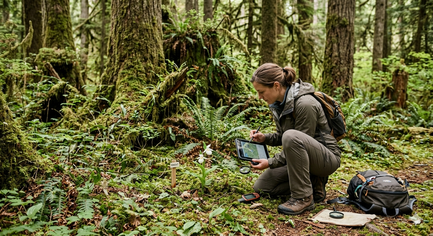
The single most important tool is your camera. A sharp, well-framed photo from 12–18 inches away captures leaf morphology, stem texture, and growth habit without any physical contact. That’s enough for species-level identification in most cases.
“When photographing an unknown plant, always take three shots: the whole plant in context, a close-up of the leaf attachment point, and the underside of a leaf. Those three images resolve about 80% of identification disputes in the field.”
Transect Surveys: The Structured Approach That Produces Real Data
Random wandering produces anecdotes. Transect surveys produce data.
A transect is a straight line you walk through a defined area, recording every plant species you observe within a set distance on either side — typically 1 meter. You mark the start and end coordinates with your GPS, walk the line slowly, and log observations at fixed intervals.
How to run a basic transect in an old-growth stand:
- Set your start point using GPS coordinates and record them in your notebook.
- Walk a straight line for 50–100 meters, staying on the transect path only.
- Every 10 meters, pause and scan 1 meter to each side. Log species, count individuals, and photograph anything unfamiliar.
- Record canopy cover, slope, and substrate type at each stop — these are the habitat variables that explain why a rare species is present.
- Upload all observations to iNaturalist with GPS tags before leaving the trailhead.
The tradeoff with transects is real: you get structured, comparable data, but you sacrifice the flexibility to follow interesting finds off-path. Stick to the line. The discipline is the point.
iNaturalist and Citizen Science: How Your Data Gets Used
iNaturalist is not just a plant ID app. It’s a live database feeding into the Global Biodiversity Information Facility (GBIF), which researchers and land managers use to track species distributions and flag conservation concerns.
When you log a verified observation of a rare species — say, Trillium persistens in a Georgia old-growth stand — that record can trigger a review by state botanists within weeks. In 2021, a cluster of iNaturalist observations from hikers in the Appalachians helped confirm a new population of Galearis spectabilis (showy orchis) in a county with no prior records, prompting a 200-acre area to be flagged for protection review.
Your photo from a Sunday hike became part of a conservation decision. That’s the actual scale of what’s possible.
Comparing Field Documentation Methods
| Method | Data Quality | Ecosystem Impact | Skill Required | Best Use Case |
| Photo + iNaturalist | High (with good photos) | Minimal | Low–Medium | General surveys, rare plant flagging |
| Transect Survey | Very High | Low if done correctly | Medium | Structured population monitoring |
| Physical Voucher Collection | Highest (herbarium standard) | High — plant removed | High | Leave to professionals only |
| eBird-style checklist | Medium | None | Low | Quick presence/absence logs |
Physical voucher collection — removing a plant specimen for herbarium documentation — is the gold standard for taxonomic certainty. But the cost is a dead plant. For rare species, that cost is unacceptable unless you’re a permitted researcher. Choosing photo documentation over voucher collection means accepting a small margin of ID uncertainty. That’s the right tradeoff.
What Does Ethical Field Behavior Look Like in Practice?
Ethics in plant monitoring isn’t abstract. It’s a set of specific behaviors.
- Never post precise GPS coordinates for rare species on public platforms — use iNaturalist’s “obscure location” feature for any species flagged as threatened or endangered.
- Stay on established paths when approaching a plant; use a telephoto or macro lens instead of stepping closer.
- Don’t remove leaves, flowers, or seeds for identification — photograph them in place.
“The biggest mistake I see from well-meaning observers is crowding a plant to get a better shot. If you’re close enough to smell it, you’re probably too close. A 200mm equivalent zoom on your phone gets you the same image without the compaction.”
Field Notes: What the Data Looks Like Over Time
The Hoh Rain Forest situation. Volunteer monitors running quarterly transects in Washington’s Hoh Rain Forest logged Botrychium fern observations across 12 transects over three years. The data showed a 23% decline in individual counts in areas with elevated visitor foot traffic — even where visitors stayed on trail. The finding prompted a 50-meter buffer zone around two documented colonies. No researcher initiated that study. Hikers with notebooks did.
Consistent, repeated observation is what turns a single sighting into a trend. A trend is what moves land managers to act.
The Bigger Picture
Every time you walk into an old-growth forest with a camera, a GPS, and a notebook, you’re doing something that matters. Not symbolically — practically. The data gap in rare plant monitoring across US old-growth systems is enormous. The USDA estimates that fewer than 15% of known rare plant populations in National Forests receive any systematic monitoring in a given year.
You can help close that gap. The methods are accessible. The tools are free or cheap. The only requirement is showing up with intention — and leaving without a trace. For species identification support, visit iNaturalist.org. For rare plant distribution data by state, the USDA PLANTS Databaseis the most comprehensive free resource available.